Showing 33 items matching surveyors level
-
 Flagstaff Hill Maritime Museum and Village
Instrument - Drainage Level, 1750-1795
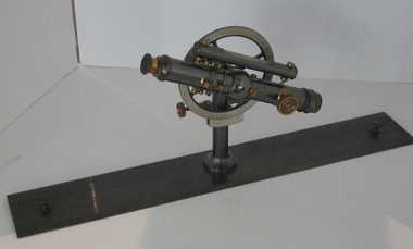
... surveyors level... instrument surveyors level george adams snr projection microscope G ...Adams jnr wrote many elementary scientific works, as well as on the use of mathematical instruments. He often combined in his written works with religious themes and scientific content, often against the prevailing thoughts of the time. According to one popular magazine of the time (Gentleman's Magazine), his works were often accused of "growing errors of materialism, infidelity, and anarchy". He started writing at a young age and developed a love for it, his main interests included math and science, these subjects he often expressed in his written essay's. Notable works from Adams are. An Essay on Electricity, and Magnetism (1784). Essays on the Microscope (1787). An Essay on Vision, briefly explaining the fabric of the eye (1789). Astronomical and Geographical Essays (1790). A Short Dissertation on the Barometer (1790). Geometrical and Graphical Essays, containing a description of the mathematical instruments used in geometry, civil and military surveying, leveling and perspective (1790). Lectures on Natural and Experimental Philosophy, in five volumes (1794).George Adams Sr and Jnr were both notable opticians and scientific instrument makers of the 18th century. Their contribution to scientific innovation and optical development cannot be underestimated. Having one of their early drainage levels in the collection and in extremely good condition is an asset to the Flagstaff collection.Drainage level or optical level. A brass surveying instrument with Achromatic telescope, bubble level and dial fitted to the Tribrach or footplate that has leveling screws. Tripod is wood and brass with adjustable and unscrewable legs (for ease of transportation). Made by "G. Adams Fleet St, London". Used in surveying and building to transfer, measure and/or set horizontal levels."G. Adams - London".flagstaff hill, warrnambool, shipwrecked-coast, flagstaff-hill, flagstaff-hill-maritime-museum, maritime-museum, shipwreck-coast, flagstaff-hill-maritime-village, george adams fleet street london, optical instrument, scientific instrument, technical instrument, surveyors level, george adams snr, projection microscope -
 Melbourne Tram Museum
Document - Research Notes, H. S. McComb, MTT & MTOCo authorised lines, c1956
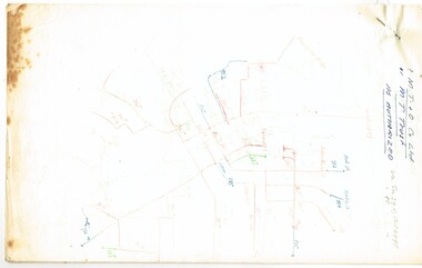
... , description, extract from surveyors level books for dates, list..., description, extract from surveyors level books for dates, list ...Notes, 13 pages foolscap sheets pinned in the top left hand corner, 2 loose foolscap pages, 6 quarto pages, providing a sketch map of the MTOCo lines as authorised, length of each line, description, extract from surveyors level books for dates, list of cable car depots and financial notes. Items 2064 to 2075 within box 72.3 in a brown folder marked "MT&O Co." red pencil on the front cover.trams, tramways, mto co, cable trams, drawings, reports, surveys -
 Federation University Historical Collection
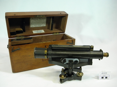
Instrument, W. H. Stanley, Surveying level, July 1899
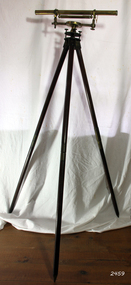
... Surveyor's level caste in metal with brass trimmings... Instrument Surveying level Surveyor's level caste in metal with brass ...Used by students attending surveying classes at the School of Mines & Industries, Ballarat.Surveyor's level caste in metal with brass trimmings. Features external focus, twin inclined vertical crosshairs with stadia wires. With ray-shade clinomenter. Three levelling screws. Without transverse level (mounting provided). dust shield for object. Features glass lens x 2. Timber carry case features dovetailed joints, separate lid attached to body of case with two brass piano hinges along back side. Case has a metal carry handle screwed to each end. Matches tripod Item 4116 Item's serial number: 99142*The timber lid of the carry case has 'L3' painted on it in white paint. *The paper label glued to reverse side lid of inside carry box reads: STANLEY'S PATENT LEVELS AND THEODOLITES No.99142 July 1899 STADIA POINTS SET=1 : 100. In taking readings of a distant staff by means of the subtense points in the diaphragm, read every 1/100 foot (or metre) on the staff as being equal to one foot (or metre) of distance from the centre of the instrument adding to the reading of plus constant of 18 3/4 inchess from any distance shown. W.F. Stanley, Great Turnstile, Holborn, London. *The paper label glued to lower edge inside lid of carry box reads: N. H. SEWARD, "Optical House" 457 BOURKE STREET (Near Queen Street) MELBOURNE *Engraving on brass plate encompassing the catch on front edge of the timber carry case reads: H&C L (inside an engraved heart on LSH) EUCHRE LEVER (engraved on RHS of brass plate) *Maker's mark is engraved along the length of the telescope barrel: 99142 Stanley. Great Turnstile Holborn, London. level, theodolite, surveying instrument, surveying, scientific instruments -
 Ballarat Tramway Museum
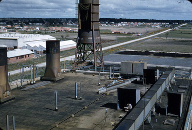
Photograph - Digital image, W. J. Llewelyn, c1980
... the surveyor and level in the middle bottom of the photograph.... - Photo taken at the same time as btm6845i.. Note the surveyor ...Yields information about the Ballarat Power Station B soon after construction and the precinct.Colour digital images taken by W. J. Llewelyn of Ballarat B Power Station, Norman St with a view showing some of the roof mounted equipment and looking towards the Wendouree suburb with Norman St in the view.. Could be early 1954, given the works at Johns Valves - Photo taken at the same time as btm6845i.. Note the surveyor and level in the middle bottom of the photograph.trams, tramways, ballarat b power station, secv, manufacturing, norman st -
 Federation University Historical Collection
Instrument - Surveyor's Instrument, Boxed Theodolite, c late 1880s
According to Max Clarke this item was used by the surveying classes at the Ballarat School of MinesA boxed (timber) theodolite with crossbars and full-length stadia wires. The theodolite can be mounted on a metal straightedge base. The box also contains a magnetic compass with two bubble levels, a plumbing folk, and 4 brass paper clips designed to suit a plan table. On box in black paint "A 1". Inside box lid is manufacturer's label and Stadia measurement zero reference calibration.ballarat school of mines, surveying equipment, gurley, max clarke, theodolite, stadia measurement, calibration, scientific instrument -
 Ringwood and District Historical Society
Administrative record - Mining Reports, Government Printer, Melbourne, Colony of Victoria quarterly and annual mining reports - 1860s 1870s & 1880s, 1865 - 1883
Colony of Victoria mining reports show any Ringwood mine references under Castlemaine District, St. Andrews Subdivision. Noteworthy for Ringwood: - Death of Pierce Boardman, mining manager at New Ringwood Mining Co., accidentally killed when he lost his footing and fell to a depth of 40 feet on 1st January 1879. - William White injured in truck accident at New Ringwood Antimony Tribute Company, 31st March 1882.Boxed collection of soft and hard bound reports including: 1. Quarterly Colony of Victoria reports of the Mining Surveyors & Registrars, Victoria, 1865-1881 - Summary of gold mining statistics for the quarter - Tables showing the yield of gold from certain parcels of quartz raised during the quarter in some of the deepest mines in Victoria with depth of the deepest shafts, levels, cross-cuts, etc. - Estimated yield of gold and quantity of gold exported during the quarter - Gold received and issued from the Royal Mint during the quarter - Summary of yield of gold from quartz, tailings, etc., crushed during the quarter - Summary of yield of gold from washdirt and cement washed and crushed during quarter - Number and distribution of miners on the goldfields of the colony. 2. 1879-82 Hard bound volume - Chief Inspector of Mines Reports to the Honorable Minister of Mines, Victoria. (Includes fatal and non-fatal accident reports, mining operations, and employment statistcs.) Noteworthy for Ringwood: - Death of Pierce Boardman, mining manager at New Ringwood Mining Co., accidentally killed when he lost his footing and fell to a depth of 40 feet on 1st January 1879. - William White injured in truck accident at New Ringwood Antimony Tribute Company, 31st March 1882. 3. Mineral Statistics for Victoria - annual reports for years 1867, 1871, 1874, 1876, 1877, 1878, & 1879. 4. Handwritten study notes.antimony, boardman, william white -
 Kiewa Valley Historical Society
Postcard Circa 1950, Lake Guy Dam and Bogong Village, Circa 1950
This postcard was produced in the 1950's for the tourist trade in the Kiewa Valley and Alpine region. It encompasses the period when the State of Victoria was pressured by the ever increasing demand by industry and its population for electricity supplies. Hydro electricity was seen as an untapped natural resource to quench this demand. The Victorian Alps and the rivers flowing into its valleys was ideal for the construction of the Kiewa Hydro Electricity Scheme. The late 1940's saw the development of this scheme and the changing of sections of alpine landscape is covered by this and other postcards/pictures (tourists, construction workers, and established rural populations). This period in time was before the established wildlife and forest/nature groups became political activist who changed legislative acts to protect the environment.This rural region (Kiewa Valley/alpine plains) was at most only significant to a smaller group of winter sports, summer hikers/horse riders and rural farmers/graziers. The numbers of tourists and the increase in the local resident population was boosted by the construction of the Hydro Electricity Scheme. This influx to the regional population resulted in a corresponding diversity in services and brought about an environment that responded to a growing level of tourists and thereby permitting this industry to grow more rapidly than it would have naturally. This postcard details an attraction to the "cleaner" method of providing electricity. This postcard was purchased in 1950 by a surveyor at Landford's Gap.This black and white photograph from a Valentine's postcard is from a V2 Argus photograph postcard. It is on a 200g/m paper density photo side gloss. See 0480 (B) - (F) for other photos of similar postcards.In white lettering " LAKE GUY & BOGONG VILLAGE KIEWA HYDRO-ELECTRIC PROJECT"kiewa valley tourism, victorian alps, alternate energy supplies, alpine population growth -
 Kiewa Valley Historical Society
Postcard Circa 1950, Snowfall at Bogong Village Kiewa Hydro-Electric Project, 1950s
This postcard was produced in the 1950's for the tourist trade in the Kiewa Valley and Alpine region. It encompasses the period when the State of Victoria was pressured by the ever increasing demand by industry and its population for electricity supplies. Hydro electricity was seen as an untapped natural resource to quench this demand. The Victorian Alps and the rivers flowing into its valleys was ideal for the construction of the Kiewa Hydro Electricity Scheme. The late 1940's saw the development of this scheme and the changing of sections of alpine landscape is covered by this and other postcards/pictures (tourists, construction workers, and established rural populations). This period in time was before the established wildlife and forest/nature groups became political activist who changed legislative acts to protect the environment.This rural region (Kiewa Valley/alpine plains) was at most only significant to a smaller group of winter sports, summer hikers/horse riders and rural farmers/graziers. The numbers of tourists and the increase in the local resident population was boosted by the construction of the Hydro Electricity Scheme. This influx to the regional population resulted in a corresponding diversity in services and brought about an environment that responded to a growing level of tourists and thereby permitting this industry to grow more rapidly than it would have naturally. This postcard details an attraction to the "cleaner" method of providing electricity. This postcard was purchased in 1950 by a surveyor at Landford's Gap.This scanned black and white photograph of a postcard, shows vehicles covered in thick snow at Bogong Village in 1950. See 0480(A), (C) - (F) for other similar photos of postcards available at this period."SNOWFALL AT BOGONG VILLAGE KIEWA HYDRO-ELECTRICITY PROJECT"kiewa valley tourism, victorian alps, alternate energy supplies, alpine population growth, bogong village, secv -
 Kiewa Valley Historical Society
Postcard Circa 1950, Scene in Bogong Village Kiewa Hydro-Electric Project, 1950s
This postcard was produced in the 1950's for the tourist trade in the Kiewa Valley and Alpine region. It encompasses the period when the State of Victoria was pressured by the ever increasing demand by industry and its population for electricity supplies. Hydro electricity was seen as an untapped natural resource to quench this demand. The Victorian Alps and the rivers flowing into its valleys was ideal for the construction of the Kiewa Hydro Electricity Scheme. The late 1940's saw the development of this scheme and the changing of sections of alpine landscape is covered by this and other postcards/pictures (tourists, construction workers, and established rural populations). This period in time was before the established wildlife and forest/nature groups became political activist who changed legislative acts to protect the environment. This rural region (Kiewa Valley/alpine plains) was at most only significant to a smaller group of winter sports, summer hikers/horse riders and rural farmers/graziers. The numbers of tourists and the increase in the local resident population was boosted by the construction of the Hydro Electricity Scheme. This influx to the regional population resulted in a corresponding diversity in services and brought about an environment that responded to a growing level of tourists and thereby permitting this industry to grow more rapidly than it would have naturally. This postcard details an attraction to the "cleaner" method of providing electricity. This postcard was purchased in 1950 by a surveyor at Landford's Gap. The couple shown in this photograph would have been employed by the S.E.C. under the Kiewa Hydro-Electricity Scheme.This item is a scanned black and white photograph of a couple walking along a gravel street in Bogong Village in 1950. See 0480 (A) ,(B), (D) - (F) for other photos of similar postcards" SCENE IN BOGONG VILLAGE KIEWA HYDRO-ELECTRIC PROJECT"kiewa valley tourism, victorian alps, alternate energy supplies, alpine population growth, bogong, secv -
 Kiewa Valley Historical Society
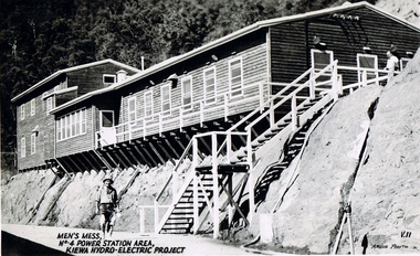
Postcard Circa 1950, Men's Mess No.4 Power Station, Kiewa Hydro-Electric Project
This postcard was produced in the 1950's for the tourist trade in the Kiewa Valley and Alpine region. It encompasses the period when the State of Victoria was pressured by the ever increasing demand by industry and its population for electricity supplies. Hydro electricity was seen as an untapped natural resource to quench this demand. The Victorian Alps and the rivers flowing into its valleys was ideal for the construction of the Kiewa Hydro Electricity Scheme. The late 1940's saw the development of this scheme and the changing of sections of alpine landscape is covered by this and other postcards/pictures (tourists, construction workers, and established rural populations). This period in time was before the established wildlife and forest/nature groups became political activist who changed legislative acts to protect the environment.Although this photo details the eating facilities of the construction workers at the power station it was not only a postcard for the people employed in the Hydro Scheme is was also provided to tourists visiting the area and thus used for promotional purposes.This rural region (Kiewa Valley/alpine plains) was at most only significant to a smaller group of winter sports, summer hikers/horse riders and rural farmers/graziers. The numbers of tourists and the increase in the local resident population was boosted by the construction of the Hydro Electricity Scheme. This influx to the regional population resulted in a corresponding diversity in services and brought about an environment that responded to a growing level of tourists and thereby permitting this industry to grow more rapidly than it would have naturally. This postcard details an attraction to the "cleaner" method of providing electricity. This postcard was purchased in 1950 by a surveyor at Landford's Gap. The men shown in this photograph would have been employed by the S.E.C. under the Kiewa Hydro-Electricity Scheme.This item is a scanned black and white photograph of a construction worker walking from stairs leading down from the men's mess building, in 1950. See 0480 (A) -(C), (E) - (F) for other photos of similar postcards"MEN'S MESS No.4 POWER STATION AREA, KIEWA HYDRO-ELECTRIC PROJECT" "ARGUS PHOTO V.IIkiewa valley tourism, victorian alps, alternate energy supplies, alpine population growth, secv -
 Kiewa Valley Historical Society
Postcard Circa 1950, Mt. Beauty Village, Kiewa Hydro-Electricity Project, circa 1950
This postcard was produced in the 1950's for the tourist trade in the Kiewa Valley and Alpine region. It encompasses the period when the State of Victoria was pressured by the ever increasing demand by industry and its population for electricity supplies. Hydro electricity was seen as an untapped natural resource to quench this demand. The Victorian Alps and the rivers flowing into its valleys was ideal for the construction of the Kiewa Hydro Electricity Scheme. The late 1940's saw the development of this scheme and the changing of sections of alpine landscape is covered by this and other postcards/pictures (tourists, construction workers, and established rural populations). This period in time was before the established wildlife and forest/nature groups became political activist who changed legislative acts to protect the environment. The regulatory pondage on the northern aspect of the village had no water over-spill from the unfinished power station.This rural region in 1950 (Kiewa Valley/alpine plains) was at most only significant to a smaller group of winter sports, summer hikers/horse riders and rural farmers/graziers. The numbers of tourists and the increase in the local resident population was boosted by the construction of the Hydro Electricity Scheme. This influx to the regional population resulted in a corresponding diversity in services and brought about an environment that responded to a growing level of tourists and thereby permitting this industry to grow more rapidly than it would have naturally. This postcard details an attraction to the "cleaner" method of providing electricity. This postcard was purchased in 1950 by a surveyor at Landford's Gap. The couple shown in this photograph would have been employed by the S.E.C. under the Kiewa Hydro-Electricity Scheme.This item is a scanned black and white photograph of a panoramic view of Mount Beauty Village in 1950 (a closed village, entry by pass only). The regulatory pondage has earthen walls but no water.See 0480 (A) -(D) and (F) for other photos of similar postcards"MT. BEAUTY VILLAGE KIEWA HYDRO-ELECTRIC PROJECT"kiewa valley tourism, victorian alps, alternate energy supplies, alpine population growth -
 Kiewa Valley Historical Society
Postcard Circa 1950, Howman Gap Hostel under snow Kiewa Hydro-Electric Project, Circa 1950
This postcard was produced in the 1950's for the tourist trade in the Kiewa Valley and Alpine region. It encompasses the period when the State of Victoria was pressured by the ever increasing demand by industry and its population for electricity supplies. Hydro electricity was seen as an untapped natural resource to quench this demand. The Victorian Alps and the rivers flowing into its valleys was ideal for the construction of the Kiewa Hydro Electricity Scheme. The late 1940's saw the development of this scheme and the changing of sections of alpine landscape is covered by this and other postcards/pictures (tourists, construction workers, and established rural populations). This period in time was before the established wildlife and forest/nature groups became political activist who changed legislative acts to protect the environment.This rural region (Kiewa Valley/alpine plains) was at most only significant to a smaller group of winter sports, summer hikers/horse riders and rural farmers/graziers. The numbers of tourists and the increase in the local resident population was boosted by the construction of the Hydro Electricity Scheme. This influx to the regional population resulted in a corresponding diversity in services and brought about an environment that responded to a growing level of tourists and thereby permitting this industry to grow more rapidly than it would have naturally. This postcard details an attraction to the "cleaner" method of providing electricity. This postcard was purchased in 1950 by a surveyor at Landford's Gap.This item is a scanned black and white photograph of a panoramic view of Howman Gap Hostel under snow in 1950 (a closed village, entry by pass only). This accommodation was for construction workers only. See 0480 (A) -(E) for other photos of similar postcards.On the photo, " Howman Gap Hostel under snow Kiewa Hydro-Electric Project" . On postcard address and personal information side "V.2 Valentine's Post Card "kiewa valley tourism, victorian alps, alternate energy supplies, alpine population growth, bogong, secv, howman's gap hostel -
 Kiewa Valley Historical Society
Sharpener Saw Raker/Jointer, early 1900s
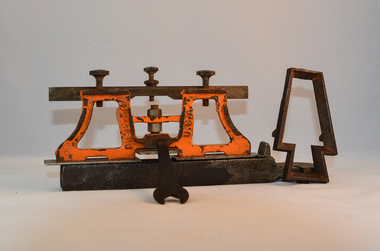
This raker/jointer/guage set is a sharpening tool for cross cut logging saws. The logging saws used in the early 1900's for the clearing of forests required constant sharpening of their "cutting teeth". The logging of forested areas during these times was very much a "hands on" method of either one or two men by the use of saw or hand axe. Chain saws, chain and ball(clearing) and bulldozing methods came in the mid 1900's.This particular saw sharpening method was used by surveyors laying down boundaries for the S.E.C. Victoria Hydro Electricity Scheme (1920's). This item was given to a local Kiewa Valley lad who accompanied the initial surveyors. The lad was responsible for the tendering and feeding of the surveyors "pack horses". Surveys during this period and in the dense mountainous terrain of the Victorian Alps was both exhausting and hazardous. Overnight accommodation at various log cabins was not always possible and swag/tent alternative was the "fall back" This raker/jointer saw sharpener was made in the USA (DISSTON) from cast and flat iron. The main body has been painted in orange. It has three adjustment screws on the top horizontal bar and one bolt on(adjusting) leveling platform on the bottom. The small size and weight of this saw sharpener was ideal for the travelling/mobile logger or surveyor(as in this case). The main frame resembles two towers connected by two horizontal bars and the top of the towers has a horizontal bar with adjustment screws. See KVHS 0090 (B) for setting stake wedge adjusting the rake and cutting angle and KVHS 0090 (C) for a small spanner (for adjustments).On one inner supports is stamped "DISSTON" and on the other "U.S.A."hand tool, saw, sharpening method, tree felling. -
 Kiewa Valley Historical Society
Postcard Circa 1950, Snow Plough, Bogong High Plain,5,500 Feet Kiewa Hydro-Electric Project, Circa 1950
This postcard was produced in the 1950's for the tourist trade in the Kiewa Valley and Alpine region. It encompasses the period when the State of Victoria was pressured by the ever increasing demand by industry and its population for electricity supplies. Hydro electricity was seen as an untapped natural resource to quench this demand. The Victorian Alps and the rivers flowing into its valleys was ideal for the construction of the Kiewa Hydro Electricity Scheme. The late 1940's saw the development of this scheme and the changing of sections of alpine landscape is covered by this and other postcards/pictures (tourists, construction workers, and established rural populations). This period in time was before the established wildlife and forest/nature groups became political activist who changed legislative acts to protect the environment. This rural region (Kiewa Valley/alpine plains) was at most only significant to a smaller group of winter sports, summer hikers/horse riders and rural farmers/graziers. The numbers of tourists and the increase in the local resident population was boosted by the construction of the Hydro Electricity Scheme. This influx to the regional population resulted in a corresponding diversity in services and brought about an environment that responded to a growing level of tourists and thereby permitting this industry to grow more rapidly than it would have naturally. This postcard details an attraction to the "cleaner" method of providing electricity. This postcard was purchased in 1950 by a surveyor at Landford's Gap. This item is a black and white photograph(professional) of a panoramic view of a snow plough clearing the unsealed road in 1950.This postcard is on quality paper and the reproduction of the picture is of a high standard.For other "tourist" postcards see 0480 (A) -(F) for other photos of similar postcards. kiewa valley tourism, victorian alps, alternate energy supplies, alpine population growth, secv, snow plough -
 Kiewa Valley Historical Society
Postcard Circa 1950, Road to Bogong High Plains Kiewa Hydro Electric Project, Circa 1950's
This postcard was produced in the 1950's for the tourist trade in the Kiewa Valley and Alpine region. It encompasses the period when the State of Victoria was pressured by the ever increasing demand by industry and its population for electricity supplies. Hydro electricity was seen as an untapped natural resource to quench this demand. The Victorian Alps and the rivers flowing into its valleys was ideal for the construction of the Kiewa Hydro Electricity Scheme. The late 1940's saw the development of this scheme and the changing of sections of alpine landscape is covered by this and other postcards/pictures (tourists, construction workers, and established rural populations). This period in time was before the established wildlife and forest/nature groups became political activist who changed legislative acts to protect the environment.This rural region (Kiewa Valley/alpine plains) was at most only significant to a smaller group of winter sports, summer hikers/horse riders and rural farmers/graziers. The numbers of tourists and the increase in the local resident population was boosted by the construction of the Hydro Electricity Scheme. This influx to the regional population resulted in a corresponding diversity in services and brought about an environment that responded to a growing level of tourists and thereby permitting this industry to grow more rapidly than it would have naturally. This postcard details an attraction to the "cleaner" method of providing electricity. This postcard was purchased in 1950 by a surveyor at Landford's Gap.This black and white photograph on a Valentine's postcard is from a V2 Argus photograph.. It is on a 200g/m paper density photo side gloss. See 0480 (A) - (G) for other photos of similar postcards.In white lettering " ROAD TO BOGONG HIGH PLAINS KIEWA HYDRO-ELECTRIC PROJECT", V3secv, road making, victorian alps -
 Kiewa Valley Historical Society
Postcard - Rocky Valley - Circa 1950, 1950
This postcard was produced in the 1950's for the tourist trade in the Kiewa Valley and Alpine region. It encompasses the period when the State of Victoria was pressured by the ever increasing demand by industry and its population for electricity supplies. Hydro electricity was seen as an untapped natural resource to quench this demand. The Victorian Alps and the rivers flowing into its valleys was ideal for the construction of the Kiewa Hydro Electricity Scheme. The late 1940's saw the development of this scheme and the changing of sections of alpine landscape is covered by this and other postcards/pictures (tourists, construction workers, and established rural populations). This period in time was before the established wildlife and forest/nature groups became political activist who changed legislative acts to protect the environment.This rural region (Kiewa Valley/alpine plains) was at most only significant to a smaller group of winter sports, summer hikers/horse riders and rural farmers/graziers. The numbers of tourists and the increase in the local resident population was boosted by the construction of the Hydro Electricity Scheme. This influx to the regional population resulted in a corresponding diversity in services and brought about an environment that responded to a growing level of tourists and thereby permitting this industry to grow more rapidly than it would have naturally. This postcard details an attraction to the "cleaner" method of providing electricity. This postcard was purchased in 1950 by a surveyor at Landford's Gap.This black and white photograph is from a Valentine's V2 Argus postcard. It is on a 200g/m paper density one side gloss. See also KVHS 0480 (A) to (L) for similar postcards. "ROCKY VALLEY FROM BOGONG HIGH PLAINS KIEWA HYDRO-ELECTRIC PROJECT" "V1"kiewa valley tourism, victorian alps, alternate energy supplies, alpine population growth, rocky valley, secv -
 Kiewa Valley Historical Society
Postcard - Junction Dam - Circa 1950, Circa 1950's
This postcard was produced in the 1950's for the tourist trade in the Kiewa Valley and Alpine region. It encompasses the period when the State of Victoria was pressured by the ever increasing demand by industry and its population for electricity supplies. Hydro electricity was seen as an untapped natural resource to quench this demand. The Victorian Alps and the rivers flowing into its valleys was ideal for the construction of the Kiewa Hydro Electricity Scheme. The late 1940's saw the development of this scheme and the changing of sections of alpine landscape is covered by this and other postcards/pictures (tourists, construction workers, and established rural populations). This period in time was before the established wildlife and forest/nature groups became political activist who changed legislative acts to protect the environment.This rural region (Kiewa Valley/alpine plains) was at most only significant to a smaller group of winter sports, summer hikers/horse riders and rural farmers/graziers. The numbers of tourists and the increase in the local resident population was boosted by the construction of the Hydro Electricity Scheme. This influx to the regional population resulted in a corresponding diversity in services and brought about an environment that responded to a growing level of tourists and thereby permitting this industry to grow more rapidly than it would have naturally. This postcard details an attraction to the "cleaner" method of providing electricity. This postcard was purchased in 1950 by a surveyor at Landford's Gap.This black and white photograph is a Valentine's postcard, from a V2 Argus photograph. It is on a 200g/m paper density with only the photo side gloss.Front "JUNCTION DAM & SPILLWAY, BOGONG KIEWA HYDRO-ELECTRIC PROJECT" on the flip side "VALENTINE'S POST CARD " "A GENUINE PHOTOGRAPH"kiewa valley tourism, victorian alps, alternate energy supplies, alpine population growth, junction dam, secv -
 Kiewa Valley Historical Society
Postcard - Junction Dam - Circa 1950, Circa 1950
This postcard was produced in the 1950's for the tourist trade in the Kiewa Valley and Alpine region. It encompasses the period when the State of Victoria was pressured by the ever increasing demand by industry and its population for electricity supplies. Hydro electricity was seen as an untapped natural resource to quench this demand. The Victorian Alps and the rivers flowing into its valleys was ideal for the construction of the Kiewa Hydro Electricity Scheme. The late 1940's saw the development of this scheme and the changing of sections of alpine landscape is covered by this and other postcards/pictures (tourists, construction workers, and established rural populations). This period in time was before the established wildlife and forest/nature groups became political activist who changed legislative acts to protect the environment.This rural region (Kiewa Valley/alpine plains) was at most only significant to a smaller group of winter sports, summer hikers/horse riders and rural farmers/graziers. The numbers of tourists and the increase in the local resident population was boosted by the construction of the Hydro Electricity Scheme. This influx to the regional population resulted in a corresponding diversity in services and brought about an environment that responded to a growing level of tourists and thereby permitting this industry to grow more rapidly than it would have naturally. This postcard details an attraction to the "cleaner" method of providing electricity. This postcard was purchased in 1950 by a surveyor at Landford's Gap.This black and white photograph on a Valentine's postcard is from a V2 Argus photograph. It is on a 200g/m paper density one side gloss only/. See 0480 (A) -(L) for other photos of similar postcards."JUNCTION DAM & SPILLWAY, LAKE GUY, BOGONG, KIEWA HYDRO-ELECTRIC PROJECT" "V5" on the flip side" VALENTINE'S POST CARD " "A GENUINE PHOTOGRAPH"kiewa valley tourism, victorian alps, alternate energy supplies, alpine population growth, junction dam, secv -
 Kiewa Valley Historical Society
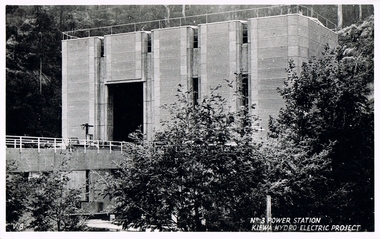
Postcard Circa 1950, No.3 Power Station Kiewa Hydro-electric Project "V.8", Circa 1950
This postcard was produced in the 1950's for the tourist trade in the Kiewa Valley and Alpine region. It encompasses the period when the State of Victoria was pressured by the ever increasing demand by industry and its population for electricity supplies. Hydro electricity was seen as an untapped natural resource to quench this demand. The Victorian Alps and the rivers flowing into its valleys was ideal for the construction of the Kiewa Hydro Electricity Scheme. The late 1940's saw the development of this scheme and the changing of sections of alpine landscape is covered by this and other postcards/pictures (tourists, construction workers, and established rural populations). This period in time was before the established wildlife and forest/nature groups became political activist who changed legislative acts to protect the environment.This rural region (Kiewa Valley/alpine plains) was at most only significant to a smaller group of winter sports, summer hikers/horse riders and rural farmers/graziers. The numbers of tourists and the increase in the local resident population was boosted by the construction of the Hydro Electricity Scheme. This influx to the regional population resulted in a corresponding diversity in services and brought about an environment that responded to a growing level of tourists and thereby permitting this industry to grow more rapidly than it would have naturally. This postcard details an attraction to the "cleaner" method of providing electricity. This postcard was purchased in 1950 by a surveyor at Landford's Gap.This black and white photograph from a Valentine's postcard is from a V2 Argus photograph postcard. It is on a 200g/m paper density photo side gloss. See 0480 (A) - (K) for other photos of similar postcards."No.3 POWER STATION KIEWA HYDRO ELECTRIC PROJECT" "V8"kiewa valley tourism, victorian alps, alternate energy supplies, alpine population growth, secv -
Koorie Heritage Trust
Book, Bonwick, James, Port Phillip settlement, 1883
Contents: Discovery; Mr. Grimes round the Bay, 1803; Settlement of 1803; The settlement of 1826; Hume and Hovell's overland journey; The Western Port settlement; Captain Sturt on the Murray; Portland Bay settlement in 1834; Major Mitchell's discoveries in Australia Felix; Life of John Batman; Batman's journal and report; The wild white man; The surveyor's note-book and report; Life of Mr. Fawkner before 1835; Fawkner on the Yarra Yarra; Official correspondence; The Port Phillip Association; Official recognition of trespassers; First Government of Port Phillip; Mr Gellibrand lost in the bush; The Governor's visit to the Yarra; Melbourne and its land sale; The stock question; Mr Mackillop's narrative; Progress of the settlement; The early Melbourne press; Discovery of Gipps Land; The Black Question; Narratives of Old Hands; Causes of emigration in 1835; An Overland journeyx, 537 pages, [36] leaves of plates (some folded.) illustrations (1 colour), facsimiles, portraits ; 23 cm.Contents: Discovery; Mr. Grimes round the Bay, 1803; Settlement of 1803; The settlement of 1826; Hume and Hovell's overland journey; The Western Port settlement; Captain Sturt on the Murray; Portland Bay settlement in 1834; Major Mitchell's discoveries in Australia Felix; Life of John Batman; Batman's journal and report; The wild white man; The surveyor's note-book and report; Life of Mr. Fawkner before 1835; Fawkner on the Yarra Yarra; Official correspondence; The Port Phillip Association; Official recognition of trespassers; First Government of Port Phillip; Mr Gellibrand lost in the bush; The Governor's visit to the Yarra; Melbourne and its land sale; The stock question; Mr Mackillop's narrative; Progress of the settlement; The early Melbourne press; Discovery of Gipps Land; The Black Question; Narratives of Old Hands; Causes of emigration in 1835; An Overland journeymelbourne (vic.) -- history -- to 1834. | melbourne (vic.) -- history -- 1834-1851. | port phillip bay region (vic.) -- history. -
Koorie Heritage Trust
Book, Baker, D.W.A, The civilised surveyor : Thomas Mitchell and the Australian Aborigines, 1997
By the 1830's the squatters were poised to extend theri runs over eastern Australia and so dispossess untold thousands of Aboriginal families of their land. Mitchell witnessed at first hand some of the worst years of a monstrous and incomprehensible disaster. More than that, his work directly assisted in this destruction.xv, 213 pages : illustrations, maps ; 22 cm.By the 1830's the squatters were poised to extend theri runs over eastern Australia and so dispossess untold thousands of Aboriginal families of their land. Mitchell witnessed at first hand some of the worst years of a monstrous and incomprehensible disaster. More than that, his work directly assisted in this destruction.mitchell, thomas, sir, 1792-1855 -- relations with aborigines, australian -- new south wales. | mitchell, thomas, sir, 1792-1855 -- journeys -- new south wales. | aboriginal australians -- new south wales -- first contact with europeans. | aboriginal australians -- first contact with europeans. -
 Kew Historical Society Inc
Photograph - 'Fernhurst', 13 Fernhurst Grove, 1978
George Wharton arrived in Melbourne in 1844. An architect and surveyor, he was appointed to lay out the 'Village of Kew' by N.A. Fenwick following the land sales of 1851. A protagonist for Kew's separation from the Boroondara District Road Board, he was elected chairman when Kew achieved municipal status in December 1860. His home, 'Fernhurst', was built in 1866 on eight acres in Studley Park, with a four-storey tower and pyramidal roof. The Italianate home was a prominent Kew landmark. It was demolished in 1979 and replaced by St Paul's College in 1980.Rare colour photograph of what was once a significant mansion in Kew.Original colour positive photograph (Kodak print) of 'Fernhurst' in 1978. Photographed by Stewart West in May 1978, one year before it was demolished, the photograph gives little idea of the large landholding once surrounding the house. Originally accessed from near the corner of Princess Street and Studley Park Road, its gardens had been subdivided in the 1900s and its footprint restricted to 13 Fernhurst Grove. Like many other grand houses, by the 1970s it had been converted into apartments. From the photograph, one can see that the house had retained many of its original features such as the distinctive tower and the wide bow-fronted verandah. The slates on the roof (apart from those on the tower) had been replaced by tiles and the cement render of the exterior painted white. Annotated reverse: "Fernhurst from higher ground level side shot / 7"fernhurst, 13 fernhurst grove -- kew (vic.), george wharton, italianate architecture, vila maria society, st paul's school for the blind -
 Kew Historical Society Inc
Photograph - 2 Young Street, Kew, Paramount Photos, 1920s
Subdivision plans are historically important documents used as evidence of the growth of suburbs in Australia. They frequently provide information about when the land was sold on which a built structure was subsequently constructed as well as evidence relating to surveyors and real estate and financial agents. The numerous subdivision plans in the Kew Historical Society's collection represent working documents, ranging from the initial sketches made in planning a subdivision to printed plans on which auctioneers or agents listed the prices for which individual lots were sold. In a number of cases, the reverse of a subdivision plan in the collection includes a photograph of a house that was also for sale by the agent. These photographs provide significant heritage information relating house design and decoration, fencing and household gardens.A prepossessing, large home constructed in the Arts and Crafts style. Located on the banks of the Yarra at 2 Young Street, Kew overlooking the factories of Richmond, the design of the house takes account of the gradient with the addition of a level below the front entrance. The elegant roof includes a number of projecting gables and dormers. The gables are typically half-timbered and rendered. In addition to the asymmetrically placed portico, there are at least two open verandas, supported by timber pillars and with roofs that reflect the overall pitch of the roof of the housereal estate photographs, 2 young street - kew -
 Flagstaff Hill Maritime Museum and Village
Tool - Spirit level, Early to mid-20th century
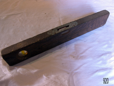
The tool is used for establishing a horizontal plane, it consists of a small glass tube containing alcohol or similar liquid and an air bubble. The tube is sealed and fixed horizontally in a wooden or metallic block or frame with a smooth lower surface. The glass tube is slightly bowed, and adjustment to the horizontal is indicated by the movement of the bubble. The device is on a level surface when the bubble is in the middle of the glass tube. The level sensitivity is proportional to the radius of the curvature of the glass. The spirit or bubble level consists of a sealed glass tube containing alcohol and an air bubble. It was invented in 1661 and was first used on telescopes and later on surveying instruments, but it did not become a carpenter's tool until the factory-made models were introduced in the mid-19th century. The circular level, in which a bubble floated under a circular glass to indicate the level in all directions, was invented in 1777. But It lacked the sensitivity of the conventional level.A hand tool that has not changed much since its invention in 1661, this tool is used today and although the materials it is made from have changed it's use has not.Spirit level wooden with two windows one of which has a piece of brass sheet metal protecting it.Noneflagstaff hill, warrnambool, flagstaff-hill, flagstaff-hill-maritime-museum, maritime-museum, shipwreck-coast, flagstaff-hill-maritime-village, hand tool, spirit level, carpenders tool, builders tool, surveyors instrument -
Federation University Historical Collection
Booklet, Instruments and Adjustments, 1865
Black covered exercise books with hand written by William Baragwanath. The handwritten notes are a copy of manuscript notes by A. Lilley Esquire and lent to Wiliam Baragwanath by J. Walker Esquire Ballarat and copied out in Septemeber 1895. Headings include: Instruments Chromatic Aberration Spherical Aberration Chromatic Spherical Aberration Notes by Professor Kernot on the Adjustment of the theodolite Sydney notes on Adjustment of Transit Theodolite Collimatino in Altitude Levelling To adjust a box sextant The Chain (Steel tape Projections of the Sphere W. Baragwanath Walhalla 1895mining, ore dressing, william baragwanath, alfred mica smith, instruments, theodolite, chain, surveyors chain, kernot, a. lilley -
 Warrnambool and District Historical Society Inc.
Book, John Ross notebook, 1890s
This small note book belonged to John Ross, the Warrnambool Town Surveyor and Engineer (1889-1906 & 1913-1914). The book lists the levels taken for the benefit of contractors undertaking jobs for the Warrnambool Council from 1898 to 1902. The jobs include ‘Russells Creek from the Merri River upwards’, ‘Outlet at the Flume’, ‘Guns at the Battery’ and Drainage from the Terminus Hotel to the end of the Japan Street Tunnel’. John Ross was also in private practice with the architectural firm of Ross and Jackman. This notebook is of considerable interest because it is an original note book that belonged to John Ross, the Warrnambool Town Surveyor and Engineer in the late 19h century and early 20th century. The note book contains important information on the engineering projects in Warrnambool and district from 1898 to 1902. This note book has a red leather cover. The cover is a little creased. The inside pages have ruled red lines and printed headings regarding the levels taken of a site and the location of the site (1898 to 1902). The engineer’s entries in the printed columns are handwritten , mostly in pencil. The inscription on the first page is handwritten in black ink. ‘Jno C Ross, Town Surveyor Wbool 19/5/98’ john ross, warrnambool town council, history of warrnambool -
 Bendigo Military Museum
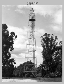
Photograph - Royal Australian Survey Corps Survey Observation Towers, c1950s
This is a set of seven photographs of Royal Australian Survey Corps surveyors setting up observation towers in the field and undertaking survey observations during mapping and geodetic control operations. c1950s. Survey observation towers were used mainly to take angular measurements in flat or heavily forested terrain, where height was necessary to achieve observer’s line-of-sight between field survey station. The Bilby Tower seen in photo .5P was erected to a height of 75 feet (23m) above ground level. The use of the Bilby Tower in Topographic Squadron’s field survey operations from 1955 to 1966 is described in page 54 of Valerie Lovejoy’s book 'Mapmakers of Fortuna – A history of the Army Survey Regiment’ ISBN: 0-646-42120-4. CAPT George Ricketts’ period of service was from 1942 to 1976 reaching the rank of LTCOL. It is noted in page 35 of Valerie Lovejoy’s book that then SGT Ricketts hand lettering skills came to the fore from his contribution to the draughting of one of the Japan’s Instruments of Surrender in 1945.This is a set of seven photographs of Royal Australian Survey Corps surveyors setting up observation towers in the field and undertaking survey observations during mapping and geodetic control operations. c1950s. The photographs were printed on photographic paper and are part of the Army Survey Regiment’s Collection. The photographs were scanned at 300 dpi. .1) - Photo, black & white, c1950s, ‘Bilby’ survey observation tower. .2) - Photo, black & white, c1950s, CAPT George Ricketts climbing ‘Bilby’ survey observation tower. .3) - Photo, black & white, c1950s, geodetic survey equipment on ‘Bilby’ survey observation tower. .4) - Photo, black & white, c1950s, two unidentified field surveyors on ‘Bilby’ survey observation tower. .5) - Photo, black & white, c1950s, two unidentified field surveyors, with CAPT Ricketts climbing ‘Bilby’ survey observation tower. .6) - Photo, black & white, c1950s, two unidentified field surveyors undertaking observations on survey observation tower. .7) - Photo, black & white, c1950, two unidentified field surveyors erecting or dismantling a survey observation tower..1P with paper tag annotated ‘Bilby Tower’ .4P on back – ‘Bilby Tower’. .5P on back – ‘Survey Observing Tower. Observing tower used for angular measurement in flat country. 75’ high – CAPT Ricketts climbing. .6P, .7P on back. ‘1960s?’royal australian survey corps, rasvy, army survey regiment, army svy regt, fortuna, asr, surveying -
The Ed Muirhead Physics Museum
Slide Rule, cylindrical / “FullerCalculator”
“FULLER CALCULATOR” : a wooden cylindrical slide rule(92.1) with spiral logarithmic scale 500 inches long. and specially made rectangular box (92.2) and pamphlet (92.3).Engraved on metal of adding machine (92.1): “8462/45” Label on inside of box: “Stanley Trademark Everything for the Engineer Architect and Surveyor in field and drawing office. W.F.Stanley & Co. Ltd, 286 High Holborn London WC1” Stamped on pamphlet: “University of Melbourne Department of Statistics” Label on top box: “display” -
 Glen Eira Historical Society
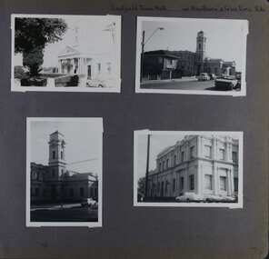
Album - Album page, Caulfield Town Hall cnr Hawthorn & Glen Eira Rds, Circa 1972
This photograph is part of the Caulfield Historical Album 1972. This album was created in approximately 1972 as part of a project by the Caulfield Historical Society to assist in identifying buildings worthy of preservation. The album is related to a Survey the Caulfield Historical Society developed in collaboration with the National Trust of Australia (Victoria) and Caulfield City Council to identify historic buildings within the City of Caulfield that warranted the protection of a National Trust Classification. Principal photographer thought to be Trevor Hart, member of Caulfield Historical Society. Most photographs were taken between 1966-1972 with a small number of photographs being older and from unknown sources. All photographs are black and white except where stated, with 386 photographs over 198 pages. Caulfield Town Hall is now known as Glen Eira Town Hall.From Victorian Heritage Database: Citation for Town Hall, Corner Glen Eira and Hawthorn Roads - HO106 https://vhd.heritagecouncil.vic.gov.au/places/43613 as at (19/10/2020) The former City of Caulfield (now City of Glen Eira) Municipal Offices, located at the south-west corner of Hawthorn and Glen Eira Roads, Caulfield South, were commenced for the Borough of Caulfield in 1884 when they also included a Post and Telegraph Office and Court of Petty Sessions. They were designed by the Borough surveyor, Sydney Smith. The hall was completed in 1890 to the design of Alexander Rankin and the present hall, foyer and portico completed to the design of Goldsmith and Jenkin, architects, in 1931. The complex is historically, aesthetically and socially significant. It is historically significant {Criterion A) as the centre of Local Government services in the area since 1885 and as a centre of post and telegraph and legal services for a period. Its association with architect and Borough surveyor, Sydney W. Smith is important in that the east elevation and facade (ground floor level only)as far west as the tower (lower two stages) survive as evidence of his work, the practice which his son continued after his death in 1886, becoming highly successful. The work of Goldsmith and Jenkin is historically important in that it indirectly demonstrates the growth of the City sustained during the Inter-war period, the work proceeding in spite of the Depression. It compares with other similar work of that time including the refurbishment of the Malvern Municipal Offices and Hall in 1927 (Hudson and Wardrop), the Melbourne Corporation Offices and Hall in 1925-28 (Stephenson and Meldrum, A. and K. Henderson) and the Camberwell Offices and Council Chamber in 1924 (Leighton Irwin and Roy Stevenson), other comparable municipal projects being undertaken during the 1930s. Finally, the Goldsmith and Jenkin works are important as a project of the Depression years organised specifically to alleviate unemployment problems in the Municipality. The complex is aesthetically important (Criterion E) as a prominent and imposing Classically derived complex of its type with individually noteworthy interior spaces being the entry hall and staircase, main Hall, Foyer and Council Chamber. The Adamesque plasterwork, timber panelling and furniture, Art Nouveaux enrichment and Classically derived treatment with sparing use of Australian decorative motifs are contributory elements. Exterior .elements of note include the remains of the original design prepared by Sydney Smith and the clock tower and portico which have come to symbolise important Municipal complexes erected prior to the Second World War. The complex is socially important (Criterion G) for the value placed on it by the community which has made use of it for activities including that of Local government for well over a century.Page 74 of Photograph Album with four photographs (three portrait and one landscape) of different views of the Caulfield Town Hall.Hand written: Caulfield Town Hall cnr Hawthorn & Glen Eira Rds [top right] / 74 [bottom right] trevor hart, caulfield, glen eira, caulfield town hall, sydney smith, sydney w smith, municipal, adamesque plasterwork, adamesque, art nouveaux, portico, council chambers, alexander rankin, foyer, local government, timber panelling, tower, unemployment, clock tower, hawthorn road, glen eira road, city of glen eira, municipal offices, post and telegraph office, goldsmith and jenkin, courthouses, surveyors, architects, classical architectural style, streetscapes, gardens, cars, glen eira town hall, depression 1929-1939 -
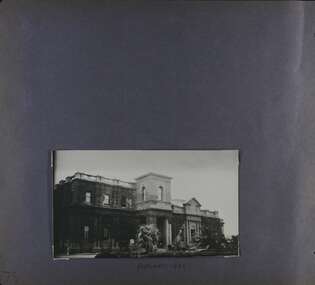 Glen Eira Historical Society
Album - Album page, Caulfield Town Hall cnr Hawthorn & Glen Eira Rds, Circa 1972
This photograph is part of the Caulfield Historical Album 1972 but is noted as taken in 1922. This album was created in approximately 1972 as part of a project by the Caulfield Historical Society to assist in identifying buildings worthy of preservation. The album is related to a Survey the Caulfield Historical Society developed in collaboration with the National Trust of Australia (Victoria) and Caulfield City Council to identify historic buildings within the City of Caulfield that warranted the protection of a National Trust Classification. Principal photographer thought to be Trevor Hart, member of Caulfield Historical Society. Most photographs were taken between 1966-1972 with a small number of photographs being older and from unknown sources. All photographs are black and white except where stated, with 386 photographs over 198 pages. Caulfield Town Hall is now known as Glen Eira Town Hall.From Victorian Heritage Database: Citation for Town Hall, Corner Glen Eira and Hawthorn Roads - HO106 https://vhd.heritagecouncil.vic.gov.au/places/43613 as at (19/10/2020) The former City of Caulfield (now City of Glen Eira) Municipal Offices, located at the south-west corner of Hawthorn and Glen Eira Roads, Caulfield South, were commenced for the Borough of Caulfield in 1884 when they also included a Post and Telegraph Office and Court of Petty Sessions. They were designed by the Borough surveyor, Sydney Smith. The hall was completed in 1890 to the design of Alexander Rankin and the present hall, foyer and portico completed to the design of Goldsmith and Jenkin, architects, in 1931. The complex is historically, aesthetically and socially significant. It is historically significant {Criterion A) as the centre of Local Government services in the area since 1885 and as a centre of post and telegraph and legal services for a period. Its association with architect and Borough surveyor, Sydney W. Smith is important in that the east elevation and facade (ground floor level only)as far west as the tower (lower two stages) survive as evidence of his work, the practice which his son continued after his death in 1886, becoming highly successful. The work of Goldsmith and Jenkin is historically important in that it indirectly demonstrates the growth of the City sustained during the Inter-war period, the work proceeding in spite of the Depression. It compares with other similar work of that time including the refurbishment of the Malvern Municipal Offices and Hall in 1927 (Hudson and Wardrop), the Melbourne Corporation Offices and Hall in 1925-28 (Stephenson and Meldrum, A. and K. Henderson) and the Camberwell Offices and Council Chamber in 1924 (Leighton Irwin and Roy Stevenson), other comparable municipal projects being undertaken during the 1930s. Finally, the Goldsmith and Jenkin works are important as a project of the Depression years organised specifically to alleviate unemployment problems in the Municipality. The complex is aesthetically important (Criterion E) as a prominent and imposing Classically derived complex of its type with individually noteworthy interior spaces being the entry hall and staircase, main Hall, Foyer and Council Chamber. The Adamesque plasterwork, timber panelling and furniture, Art Nouveaux enrichment and Classically derived treatment with sparing use of Australian decorative motifs are contributory elements. Exterior .elements of note include the remains of the original design prepared by Sydney Smith and the clock tower and portico which have come to symbolise important Municipal complexes erected prior to the Second World War. The complex is socially important (Criterion G) for the value placed on it by the community which has made use of it for activities including that of Local government for well over a century.Page 75 of Photograph Album with one portrait photograph of the exterior of Caulfield Town Hall taken in 1922.Hand written: FEBRUARY 1922 [under photo] / 75 [bottom left] trevor hart, caulfield, glen eira, caulfield town hall, sydney smith, sydney w smith, adamesque plasterwork, art nouveaux, portico, council chambers, alexander rankin, foyer, local government, timber panelling, tower, unemployment, clock tower, hawthorn road, glen eira road, city of glen eira, municipal offices, palms, gardens, post and telegraph offices, goldsmith and jenkin, architects, city of caulfield, ivy clad walls, surveyors, depression 1929-1939, glen eira town hall